1750년대 유럽에서 독도를 한국 영토를 인식한 지도가 공개됐다. A European map from the 18th century recognizes Dokdo Island as Korean territory.
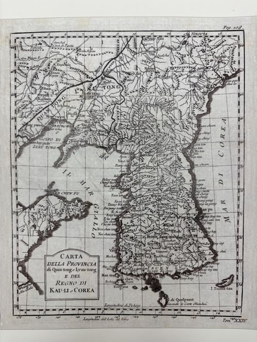
동북아역사재단 독도체험관은 ‘이달의 고지도’로 1750년 프랑스에서 제작된 ‘관동, 요동 및 조선 지도’ 이탈리아어판을 선정했다고 26일 밝혔다.
Dokdo Museum Seoul at the Northeast Asian History Foundation in Seoul on Nov. 26 said it chose the Italian version of Carte de la Province de Quan-tong ou Lyau-tong et du Royaume de Kau-Li ou Coree (Map of Quantong or Liandong Province and Kingdom of Joseon or Korea), a map produced in France in 1750, as the museum’s “Old Map of the Month.”
프랑스 왕실 수로학자 자크 니콜라 벨렝이 제작한 이 지도에는 울릉도, 독도, 한국해가 표기됐다. Made by French royal hydrographer Jacques Nicolas Bellin, the map clearly marks the islands of Ulleungdo and Dokdo and the Sea of Korea (now the East Sea).
벨렝의 지도 속 한반도의 모습은 프랑스 지리학자 당빌의 ‘조선왕국도’에 묘사된 한반도와 유사하다. 조선과 청나라의 국경은 당빌의 지도와 비슷하게 북쪽으로 치우쳐 있다. 녹둔도를 포함한 두만강 동쪽 지역도 조선의 영토로 표시됐다. 울릉도, 독도, 한국해는 각각 Fang-ling-tau, Chiang-san-tau, Mar di Corea로 표기됐다.
Bellin’s display of the Korean Peninsula closely mirrors that of the French geographer Jean Baptiste Bourguignon D’Anville’s Royaume de Coree (Map of Joseon Kingdom). The former map has the border between Joseon and the Qing Dynasty of China is tilted north, similar to the latter, and the area east of the Tumen River including Nokdundo Island is also labeled Joseon territory.
‘관동, 요동 및 조선 지도’는 오는 12월 31일까지 독도체험관 ‘독도의 역사’ 코너에 전시된다. Ulleungdo is marked as Fang Ling Tau, Dokdo Chiang-san-tau and the East Sea Mer di Corea. The museum through Dec. 31 will display the map at its Dokdo history corner.
이다솜 기자 dlektha0319@korea.kr
By Lee Dasom, dlektha0319@korea.kr
